Topographical Land Surveyors: Tools, Techniques, and Benefits Explained

In the realms of construction, land development, environmental management, and urban planning, understanding the physical characteristics of a site is crucial. This knowledge is chiefly provided by topographical land surveyors professionals who specialize in capturing precise data about a land parcel’s surface features, elevations, and contours. Their expertise informs critical decisions that affect the success, safety, and sustainability of projects.
This article delves into the essential tools, techniques, and benefits associated with topographical land surveyors, shedding light on how their work underpins effective project planning and execution.
Who Are Topographical Land Surveyors?
Topographical land surveyors measure and map the three-dimensional aspects of the land’s surface. Their focus is not on legal boundaries, but on the physical features of the site, including natural terrain, vegetation, water bodies, and man-made structures. The resulting maps and models provide a detailed representation of the land’s form and features, which are indispensable for architects, engineers, planners, and developers.
Essential Tools Used by Topographical Land Surveyors
Accurate topographical surveys depend on sophisticated tools and technology that allow surveyors to collect detailed and reliable data efficiently.
1. Total Stations
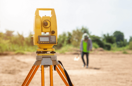
Total stations are versatile electronic instruments that combine the functions of a theodolite and an electronic distance meter. They measure horizontal and vertical angles and distances from a fixed point, allowing surveyors to determine precise coordinates of site features.
2. Global Positioning System (GPS)
Survey-grade GPS receivers capture accurate geographic coordinates by communicating with multiple satellites. GPS is especially useful for surveying large areas or difficult terrains where traditional line-of-sight measurements may be challenging.
3. 3D Laser Scanning (LiDAR)
Light Detection and Ranging (LiDAR) technology uses laser pulses to measure distances to the earth’s surface, generating dense point clouds that produce detailed 3D models of terrain and features. LiDAR is invaluable for capturing complex landscapes rapidly and with high precision.
4. Drones (Unmanned Aerial Vehicles – UAVs)
Equipped with high-resolution cameras and sensors, drones collect aerial imagery and conduct photogrammetric surveys. They efficiently cover large or inaccessible areas, providing data that can be processed into accurate topographic maps and 3D models.
5. Photogrammetry Software
This software processes overlapping photographs—typically captured by drones—to create detailed three-dimensional representations of the land surface. Photogrammetry complements other data collection methods by providing visual context and surface detail.
6. Computer-Aided Design (CAD) and Building Information Modeling (BIM) Software
After data collection, surveyors use CAD and BIM platforms to transform raw measurements into usable maps, plans, and digital terrain models. These tools enable integration with design and engineering workflows, facilitating collaboration among project stakeholders.
Key Techniques in Topographical Land Surveying
Topographical surveyors employ a combination of field techniques and data processing methods to ensure accurate, comprehensive results.
Field Surveying
Surveyors use total stations, GPS units, and laser scanners on site to measure elevations, distances, and feature locations. They often establish control points—known reference locations—to anchor the survey spatially and ensure consistency.
Aerial Surveying
Using drones or manned aircraft equipped with LiDAR or photogrammetry equipment, surveyors capture large-scale data rapidly. This method is particularly useful for extensive sites, rough terrain, or areas where ground access is limited.
Data Processing and Modeling
Raw data collected from the field and aerial sources undergo processing through specialized software. This step involves cleaning, aligning, and converting data into contour lines, 3D point clouds, or surface models. Surveyors also annotate maps with feature descriptions and measurements relevant to the project.
Quality Assurance
To guarantee accuracy, surveyors cross-verify data with existing maps, conduct repeated measurements, and apply rigorous quality control protocols. Ensuring data integrity is crucial for the dependability of the survey outputs.
Benefits of Using Topographical Land Surveyors
Engaging expert topographical land surveyors offers numerous advantages that enhance the success of construction, planning, and environmental projects.
1. Accurate Site Representation
Topographical surveys provide precise and comprehensive data about land elevations, contours, and features. This information forms the backbone of design and engineering processes, ensuring plans reflect real-world conditions.
2. Informed Decision-Making
Having detailed terrain information allows developers, architects, and planners to make sound decisions regarding site layout, building positioning, infrastructure placement, and environmental conservation.
3. Cost and Time Efficiency
Accurate surveying minimizes costly errors during construction by identifying potential challenges early. It also enables more precise earthwork calculations, reducing waste and optimizing resource allocation.
4. Regulatory Compliance
Topographical surveys are often required for permit applications and environmental assessments. Providing detailed, certified data helps meet legal requirements and expedites approval processes.
5. Risk Reduction
Surveyors identify risks such as flood-prone areas, unstable slopes, or hidden utilities, enabling teams to develop mitigation strategies before construction begins. This foresight improves safety and reduces liability.
6. Environmental Protection
Detailed surveys help protect sensitive natural features by informing sustainable site design and environmental management plans, promoting harmony between development and nature.
Practical Applications of Topographical Land Surveying
The data provided by topographical land surveyors supports a wide range of industries and projects:
- Land Development: Site planning, subdivision design, and infrastructure layout
- Construction: Foundation design, grading, drainage, and earthworks
- Environmental Management: Conservation planning, erosion control, and stormwater management
- Agriculture: Irrigation planning and land management
- Mining and Resource Extraction: Site mapping and operational planning
- Transportation: Road and railway design aligned with terrain conditions
Conclusion
Topographical land surveyors play a pivotal role in transforming raw land data into actionable insights that drive successful construction, development, and environmental projects. Their use of advanced tools and refined techniques ensures that terrain is accurately mapped, enabling informed decisions that save time, reduce costs, and mitigate risks.
Whether you are embarking on a small-scale residential development or a large infrastructure project, partnering with skilled topographical land surveyors ensures your work rests on a solid foundation of precision and reliability.


